Chain Surveying Methods & Equipments with Benefits
It is not possible to measure angles in the field by using the chain or tape measures. The ground measures with a chain or tape measure over a series of straight lines and all fixed points are measured at right angles or by tie-lines.
Equipment for Chain Surveying
1. Chain
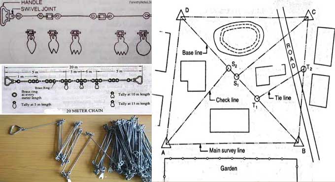
Links and rings of steel wire form a chain that folds. As a measurement unit, it can sometimes be used. Handles are attached to both ends so that they can be handled easily. A 200mm diameter link is 0.2m long. 20m or 30m is the length.
2. Ranging Poles & Rods
Poles
The top of a range pole is about 2m long, and the pole is made from wood or light metal. Steel shades are fitted over the legs of the equipment to prevent it from sliding. Red and white are the colors of range poles to make them visible even at a distance. Stations can be constructed using them.
Rods
A 3m offset rod is similar to a ranging rod. By using the hook, it is possible to push and pull chains through hedges and other obstructions. The rod generally uses to assess nearby offsets. A second slot in the center is set at an angle to the offset line. So it runs through the center of the section.
3. Offset Rods
As with a ranging rod, an offset rod has a length of 3m. At one end, they are round wooden rods attached to pointed iron shoes, and at the other, they are mounted with a hook or a notch.
Chains can be pulled and pushed through hedges and other obstacles with the hook. Nearby offsets generally assess with the rod. In addition, it has two narrow slots in the center that pass through the center of the section and are set at right angles to each other to align the offset line.
4. Arrows
Each arrow has a red cloth tied to its end to facilitate visibility. The steel wire used for making arrows is 4mm in diameter. These diagrams depict locations on the ground. They can also be used to count chains on a chain line.
5. Tape
A tape measures short distances and is made of fiberglass or steel, is 10 meters or more long, is divided into 10mm units, and numbered in a 100mm interval.
6. Notebook with Pencil & Rubber
Fieldwork records data obtained in notebooks. In terms of size and quality, the notebook should be 150x100mm. Pencils are used to draw the field, and rubbers are used to erase mistakes and errors. It is best to use HB pencils.
7. Cross staff
With its eye slips that position at right angles on either side, the cross-staff measures the angle between two lines.
8. Band of Surveyor
A steel band used by surveyors consists of a steel strip rolled into a metal frame and attached to a winding handle. The length can be 30m, 50m, or 100m. When a more accurate measurement is needed, it uses.
9. Pegs
In surveys, wood pegs with 40 mm squares and 50 cm long are used as markers to indicate permanent locations.
10. Plumb BOB
When chaining on sloped grounds, plumb bobs are required. Several instruments can be centered with its help, including compass, plane table, and a variety of others. Additionally, the ranger can be used to center points from a line ranger.
Methods of Chain Surveying
Three people are required to be part of the survey team: the chairman or leader, the follower, and the booker. Chains are thrown to disentangle knots and extend them. Both leaders and followers take a ranging rod and ten arrows.
After erecting their ranging rods or poles, the follower places the brass handles of the chains against their ranging rods. At each end of the brass handle, the leader inserts an arrow and straightens the chain.
There are now tie lines and offsets available. When the leader lets go of the chain, the follower situates his arrow behind the leader's arrow; the leader moves to another point and the follower places the ranging pole behind the arrow.
Benefits of Chain Surveying
It can be used on relatively open land in small areas. This method fills in details on maps whose large features have already been surveyed by other methods.
In addition to mapping flat or near-flat ground and associated objects, like roads and railways, it can also be used for calculating gradients. Maps and plans can be further detailed using it.
Conclusion
Indirect measurement, Chaining is the most accurate method to measure distance, whether using a chain or a tape. A tape or bar may be used instead of a chain for work of ordinary precision to achieve a high degree of precision. Chaining determines the distance for surveying. Using angle measurements is not as precise as Chaining, no matter how accurate.
Video Source: CE Quick Solution


